How to Get to Route 66 from Los Angeles [2025 Guide]
Want to start your Route 66 adventure? This 2025 guide shows you exactly how to get to Route 66 from Los Angeles—by car, bus, or tour—plus maps, tips, and FAQs for your road trip.
🛣️ Why Start Route 66 from Los Angeles?
Route 66, also called the Mother Road, is one of the most iconic highways in the United States. It originally stretched from Chicago to Santa Monica, and while the official highway was decommissioned in 1985, much of it still exists as a historic route.
Los Angeles is the western terminus of Route 66, making it the perfect place to begin (or end) your road trip. The road technically finishes at the Santa Monica Pier, but you can also access Route 66 from multiple points across LA.
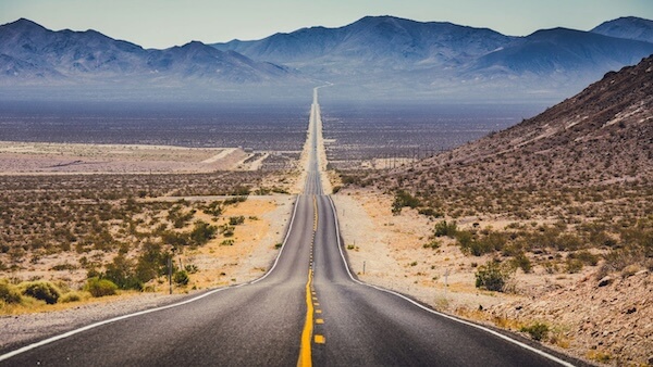
🚗 Option 1: Driving from Los Angeles to Route 66
Driving is the most authentic way to experience Route 66.
- Starting Point: Santa Monica Pier (Route 66 “End of the Trail” sign)
- Distance from Downtown LA: ~15 miles (25 km)
- Driving Time: 30–40 minutes depending on traffic
- Route: From Downtown LA, take I-10 West → Santa Monica → follow Ocean Ave to Santa Monica Pier
👉 Many travelers also drive east from LA on Route 66 (via Pasadena, San Bernardino, and Barstow) if they’re beginning a cross-country journey to Chicago.
🚌 Option 2: Bus from Los Angeles to Route 66
If you don’t have a car, you can still reach Route 66 by public transportation.
- Metro Bus & Rail: Take the Metro Expo Line (E Line) from Downtown LA to Santa Monica (about 45–50 minutes).
- Cost: $1.75 per ride (2025 fare)
- Final Stop: Downtown Santa Monica Station, a short walk to Santa Monica Pier (Route 66 endpoint).
👉 This is the cheapest way to touch Route 66 from Los Angeles.
✅ Compare the best hotel deals in your destination before you book..
🚐 Option 3: Route 66 Tours from Los Angeles
Guided tours are a great option if you want history, storytelling, and photo stops.
- Day Tours: Cover Santa Monica, Pasadena, San Bernardino, and part of Route 66.
- Multi-Day Tours: Some companies offer LA to Chicago Route 66 road trips.
- Cost: $80–$150 for day trips; $2,000+ for full cross-country tours.
👉 Perfect for those who want a hassle-free experience with expert guides.
✈️ Option 4: Fly and Start Route 66 Elsewhere
If your plan is to drive Route 66 eastbound, you can also fly from Los Angeles to a starting point like Chicago, Albuquerque, or Oklahoma City and then drive westward.
- Flights: LAX → Chicago (ORD/MDW) ~4 hours, from $120–$250 (2025 fares)
- Car Rental: Pick up a car in Chicago to drive the full Route 66 westbound ending in Santa Monica.
👉 Best for travelers who want the classic full-route experience.
📊 Travel Options Comparison
| Option | Time | Cost (One Way) | Best For |
|---|---|---|---|
| 🚗 Drive (Downtown LA → Santa Monica Pier) | 30–40 min | $10–$20 (gas/parking) | Road trippers |
| 🚌 Metro (E Line) | 45–50 min | $1.75 | Budget travelers |
| 🚐 Route 66 Tour | 1 day–2 weeks | $80–$2,000+ | Guided experience |
| ✈️ Fly to Chicago | 4+ hrs | $120–$250 | Full Route 66 journey |
📍 Key Route 66 Stops Near Los Angeles
If you’re beginning your journey from LA, here are some must-see stops before you leave California:
- Santa Monica Pier – Official Route 66 endpoint sign
- Pasadena – Historic Colorado Boulevard section of Route 66
- San Bernardino – Original McDonald’s site (now a museum)
- Elmer’s Bottle Tree Ranch (Oro Grande) – Folk art stop along Route 66
- Barstow Route 66 Mother Road Museum – Packed with history and memorabilia
✅ Compare the best hotel deals in your destination before you book..
🛂 Tips for Driving Route 66 from Los Angeles (2025)
- Traffic: Leave early if heading to Santa Monica; LA traffic can add hours.
- Parking: Paid parking lots at Santa Monica Pier ($10–$20).
- Maps: Download offline Route 66 maps or use apps like Roadtrippers.
- Car Rentals: If you’re flying into LA, rent a car with unlimited mileage for a longer road trip.
🌤️ Best Time to Drive Route 66 from Los Angeles
- Spring (March–May): Mild weather, fewer crowds.
- Summer (June–August): Popular, but hot inland.
- Fall (September–October): Pleasant weather and lighter traffic.
- Winter (November–February): Cooler, but still driveable year-round.
🙋 FAQs About Getting to Route 66 from Los Angeles
1. Where does Route 66 start in Los Angeles?
Route 66 officially ends at the Santa Monica Pier, where you’ll find the famous “End of the Trail” sign.
2. How far is Route 66 from Downtown Los Angeles?
It’s about 15 miles (30–40 minutes by car) to Santa Monica Pier.
3. Can you get to Route 66 by public transport from LA?
Yes, take the Metro E Line from Downtown LA to Santa Monica for just $1.75.
4. Can I drive Route 66 eastbound from Los Angeles?
Yes, many travelers begin in LA and drive east through Pasadena, San Bernardino, Barstow, and beyond.
5. Is Route 66 still drivable in 2025?
Yes! While it’s no longer an official U.S. highway, most sections are preserved as Historic Route 66.
6. How long does it take to drive all of Route 66?
A full trip from LA to Chicago usually takes 2–3 weeks depending on stops.
7. What’s the cheapest way to reach Route 66 from Los Angeles?
The Metro E Line to Santa Monica is the cheapest option at under $2.
✅ Final Takeaway: In 2025, getting to Route 66 from Los Angeles is simple—just head to the Santa Monica Pier to touch the official end point, or drive east through Pasadena and San Bernardino to start your Mother Road adventure. Whether you go by car, bus, tour, or even fly to Chicago, Route 66 is waiting for you.